Flat earthers are often presented with forward to back evidence of curvature like the bottom of a city being obscured behind the curve. They attempt to create ad hoc excuses that have no known physical phenomenon or deflect and change the topic demanding to see left to right curve. While there is no rational flat earth answer to the front to back curve, it is quite possible to identify the left to right curve.
At low elevations the left to right curve is very slight. At elevation, like from a commercial airplane at 35,000 to 40,000 feet, it is more pronounced but still slight and works better with a wide view of the horizon, difficult through an airplane window. There are high altitude balloon examples from 120,000 feet that are possible to see but doubts are always cast because of the properties of camera lenses.
GoPro cameras have strong barrel distortion, as do most wide-angle lenses. In fact it is actually impossible to get a camera and lens combination that doesn’t experience some sort of distortion. There is excellent professional photography software that corrects distortion for certain camera and lens combinations, but these are expensive camera and lenses that rarely would find themselves in a 120,000-foot high balloon.
Even with software-based correction, the adjusted image’s distortion may be inside the margin of error for the curve. We could take photographs from higher elevations like the International Space Station, even with strongly distorted lenses the curve of the earth is apparent. However, flat earthers like to dismiss these as CGI. Hilariously they dismiss this without forensic analysis of the images to support their claim of CGI.
Even though the burden of evidence has been thoroughly met, it’s still academically interesting to photographically capture the left to right curvature of the earth. To neutralize the effects lens distortion we need an external reference that is known to be straight. This allows us to differentiate a curve supplied by the camera and lens from the actual curve.
YouTuber Rory has set up this exact measurement. He calls it the Horizon-o-Matic 6000, an upgrade from the Horizon-o-Matic 5000. This has two straight edges fixed together with a gap between them. This allows the horizon to be photographed between the two straight edges. When examining the photograph we can be assured the straight edges are truly straight and any curve identified between them is true curve.
Here is an example of the setup before aligning the horizon between the straight edges.
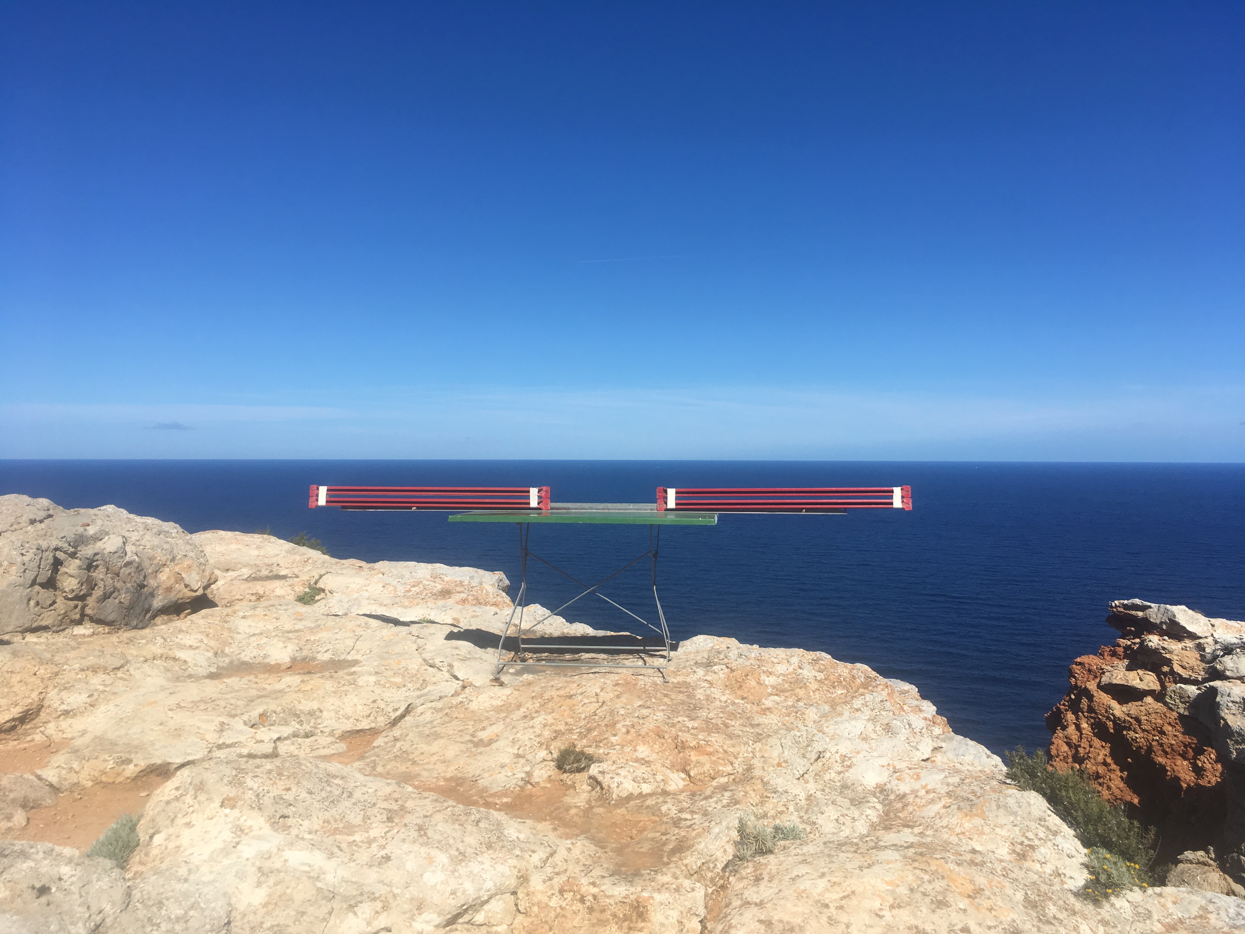
Here is the setup with the horizon carefully aligned between the straight edges.

The curve is slight but when zoomed in you can see the distance between the straight edge and the horizon changes across the image. To do this you can zoom in and measure the distance from the edge to the horizon and scroll left to right comparing. Feel free to download the image and scrutinize it. The EXIF information has been preserved including the GPS coordinates and elevation where the photographs were taken.
The images were taken on the island of Ibiza at 39° 2′ 30.24″ N, 1° 18′ 47.388″ E at an elevation of 603 feet. Feel free to download the image and look at the EXIF information.
There are some techniques to make the left to right curve easier to visualize other than zooming and panning. For example, if we simply compress the image horizontally we are able to see the curve much easier. This is not any sort of manipulation technique, it just allows the entire zoomed-in photograph to be compared in one image. Here is the photo with straight edges cropped and horizontally compressed:

We can see the straight edges are straight and the horizon is curved. Solid evidence of left to right curve.
Feel free to download the original photograph and do your own compression. Better yet, count the pixels from the straight edge to the horizon and plot on a graph.
Of course, no flat earther will accept this. It violates their pre-selected outcome. They will claim they don’t see the curve, attempt to change the subject, start calling names, run away, make accusations of tampering. Never will a flat earther be honest and face this photograph. Remember, the ultimate victory is when a flat earther blocks you, that’s how they concede defeat.
So, I challenge honest flat earthers to have the courage to reproduce this experiment. Find a place 500 feet or higher where you can easily see the horizon. Pick a day with minimal weather variances. Get two straight edges such as 8-foot metal spirit levels. Place uniform spacers between them and strap or tape them firmly together. Set this up in a way that makes it easy to adjust the straight edges so they can be lined up with the horizon. Use a good camera and take a photo from a good distance so both the straight edges and the horizon are in focus. Take many photos. Then compare the straight edge to the horizon.
