This is a list of the different experiments that will be performed on The Final Experiment trip. The globe prediction is listed as is the flat earth prediction.
Note: the flat earth prediction is based on physics, optics, and geometry. If flat earthers think these predictions are incorrect, please email me with the correct physics, optics, and geometry.
- 24 hour circling sun
- Globe prediction: 24 hours circling sun
- Local solar noon: 34° elevation
- Local solar midnight: 13° elevation
- Flat prediction:
- the sun will set
- or
- the sun will be due north at local solar noon, north west 6 hours later, due north 12 hours later, north east 18 hours later
- Animation applying flat earth geometry in Blender by Ole D’Haeseleer: https://youtu.be/073a4TpBudw
- Things to test for:
- Sun simulator, a solar filter will identify if something other than the real sun is visible. This is validated by comparing sunspots with photographs taken by other people aroung the world over the same time period.
- Sun spots mirrored at local solar midnight, this tests if the sun is reflecting off something or is directly observed.
- People participating can email photos to sun@mctoon.net. Include date, time, latitude, longitude, and camera/lens details. Be certain to use a solar filter and properly expose the photo to clearly see the sunspots.
- Globe prediction: 24 hours circling sun
- Magnetic field of the earth
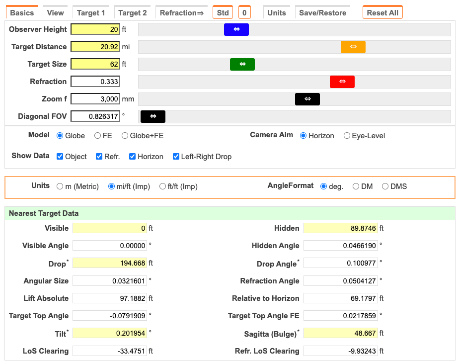
- Faro Bahía Porvenir lighthouse from Punta Arenas bottom up obstruction
- 20.92 miles
- Observer: 20 feet elevation – approximate, to be updated when the observation is performed.
- Base of Faro Bahía Porvenir lighthouse focal Height: 19 meters – 62 feet
- https://deepfo.com/en/most/lighthouses-of-Glass-fiber
- Heading angle to see Lighthouse from Hotel:
- 150°
- Globe Prediction:
- All of the light house hidden for Coefficient of Refraction k=+0.333
- 4 feet of the top visible for Coefficient of Refraction k=+0.500
- Flat prediction:
- 0.0 feet hidden
- Sunrise and sunset time and azimuth
- Globe Prediction: https://www.timeanddate.com/sun/chile/punta-arenas?month=12&year=2024
- December 10 Sunrise: 5:11am 132°, Sunset: 10:02pm 228°
- December 11 Sunrise: 5:11am 132°, Sunset: 10:03pm 228°
- December 12 Sunrise: 5:11am 132°, Sunset: 10:04pm 227°
- December 13 Sunrise: 5:11am 133°, Sunset: 10:05pm 227°
- December 14 Sunrise: 5:11am 133°, Sunset: 10:06pm 227°
- December 18 Sunrise: 5:11am 133°, Sunset: 10:09pm 227°
- December 19 Sunrise: 5:12am 133°, Sunset: 10:10pm 227°
- December 20 Sunrise: 5:12am 133°, Sunset: 10:10pm 227°
- Flat Prediction:
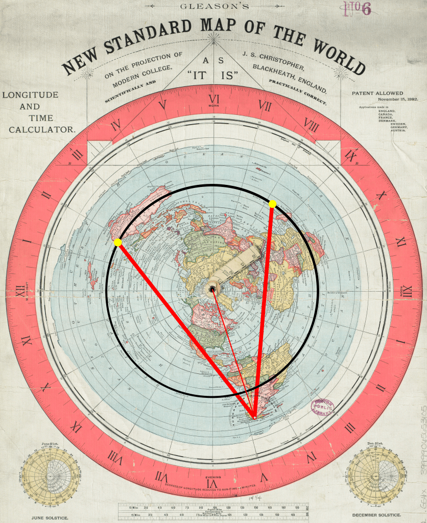
- Flat earth predicts NO sunset ever so there is no time prediction, however we can use the globe time, which is known to match reality, and determine the azimuth for sunrise and sunset times for the days near the solstice. The sun is up for about 17 hours, sunrise is 8.5 hours before local solar noon, the Gleason map has easy time indicators Map is posted below with measurements. Since there is zero geometry for flat earth provided by “flat earth scientists” these value are approximate.
- Sunrise: 23° ±1°
- Sunset: 341° ±1°
- Globe Prediction: https://www.timeanddate.com/sun/chile/punta-arenas?month=12&year=2024
- Line of sight to Polaris
- Globe prediction: Not visible: blocked due to the globe being in the way
- Flat earth prediction: Punta Arenas is 53°S, Polaris is 3105 miles in elevation over the North Pole 9,867 miles due north, therefore Polaris must be 16.9° elevation.
- Star trails looking south
- Globe prediction: a single center of rotation due south
- Flat earth prediction: horizontally moving stars due south
- Angular width of the sun in Punta Arenas and Antarctica
- Globe prediction: the angular width varies by only 2 hundredths of a degree: 0.5242° to 0.5422°.
- Flat prediction: the angular width varies by 2x-4x throughout the day
- Start with the known angular size of the sun of 0.5° at local solar noon. Determine the straight line distance for the observer to the sun at 5000km high. Determine the straight line distance for the sun 6 hours before and after local solar noon to get the new angular width.
- To determine the latitude of the sun: summer_solstice_latitude = 23.43605°, total_days = 182.5, day_offset = how many days from solstice:
solar_latitude = summer_solstice_latitude * math.cos((day_offset / total_days) * math.pi)
- Local Solar Noon: 0.5°
- 6 hours Earlier/Later the sun is 90° around the Circle it transits. This varies per day, it’s a sine/cosine variation peaking on the solstices.
- December 12: Sun latitude: 22.9°S +-0.1°
- Punta Arenas: -53.16°, -70.90°
- Local solar noon straight line distance to the sun:
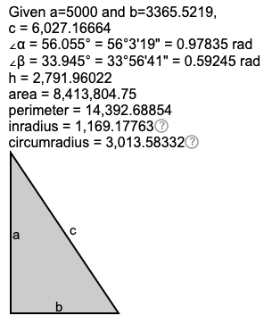
- Distance across surface: 53.16° – 22.9° = 30.29°
- 30.29 * 111.11km/° = 3365.5219km.
- Flat earth’s sun elevation is 5000km, triangulate and solve for the hypotenuse: 6,027.16664km. See diagram below.
- Round to 3 sigfig:
- 6,027km straight line from Punta Arenas to the sun for flat earth.
- Or use this python program that converts polar coordinates to cartesian coordinates and applies the Pythagorean theorem in 3 dimensions to get 6,025km.
- Set this as the base case for 0.5° angular width.
- 6 hours later and 6 hours earlier straight line distance to the sun:
- 6 Hours later the sun will move 15*6 degrees in longitude to -160.90
- Straight line distance: 20,866 km
- Use the Angular diameter formula: θ = 2 arcsin(d/2D)
- θ = angular width of the sun
- d = linear diameter of the sun
- D = straight line distance to the sun
- Note: arcsin() is used instead of arctan() because the sun is spherical.
- Solve for d = 2sin(θ/2) / D
- Linear diameter of the sun for local solar noon: 52.5779km
- Plug in linear diameter for 6 hours later to get predicted θ
- θ = 2 arcsin(d/2D) = 0.144373 round to 2 sigfig: 0.14°
- The flat earth predicted angular width of the sun 6 hours before and after local solar noon is 0.14°
- People participating can email photos to sun@mctoon.net. Include date, time, latitude, longitude, and camera/lens details. Be certain to use a solar filter and properly expose the photo to clearly see the sunspots.
- Distance between lines of longitude
- Globe prediction method
- d = r cos(latitude) * π/180
- d is arc distance
- r is radius of the globe
- Flat prediction method
- d = L * pi/180
- L = distance from north pole = degrees latitude from north pole * 60NM (or 111.12km)
- Santiago
- Globe: 92.83km
- Flat: 239.32km
- Punta Arenas
- Globe: 66.67km
- Flat: 277.65km
- Antarctica
- Globe: 19.79km
- Flat: 329.21km
- Globe prediction method
- Celestial navigation in Punta Arenas
- Globe prediction: Celestial navigation will generate an accurate position fix
- Flat earth prediction: None. There is no celestial navigation using flat earth.
- Dip of the horizon
- Globe Prediction based on the elevation
- 33,000 feet – No refraction: 3.2°, refraction: 2.9°
- 35,000 feet – No refraction: 3.3°, refraction: 3.0°
- 37,000 feet – No refraction: 3.4°, refraction: 3.1°
- 40,000 feet – No refraction: 3.5°, refraction: 3.2°
- 50,000 feet – No refraction: 4.0°, refraction: 3.6°
- 60,000 feet – No refraction: 4.3°, refraction: 4.0°
- 70,000 feet – No refraction: 4.7°, refraction: 4.3°
- 80,000 feet – No refraction: 5.0°, refraction: 4.6°
- 90,000 feet – No refraction: 5.3°, refraction: 4.8°
- 100,000 feet – No refraction: 5.6°, refraction: 5.1°
- 110,000 feet – No refraction: 5.9°, refraction: 5.4°
- 120,000 feet – No refraction: 6.1°, refraction: 5.6°
- Flat Prediction based on elevation and latitude
- See table below
- Angle = arctan(height/distance to ice wall)
- People can participate by sending photos to dip@mctoon.net. Be certain to have a crisp horizon and a steady phone while measuring. You can use “Theodolite” app on iPhone and “Dioptra” or several others on Android.
- Globe Prediction based on the elevation
- Weight variation
- Using a 1000g test mass, weigh the mass at a starting location and determine the variation at different latitudes.
- Globe prediction varies based on latitude due to the rotation and the oblateness of the Earth:
- Calibrated at Brisbane, Latitude 27.24, Elevation 19m: 1000.01 grams
- Sydney 1000.55 grams
- Santiago 1000.36 grams
- Punta Arenas 1002.29 grams
- Union Glacier 1003.80 grams
- Flat prediction does not vary due to stationeryness of the earth:
- Sydney 1000.01 grams
- Santiago 1000.01 grams
- Punta Arenas 1000.01 grams
- Union Glacier 1000.01 grams
- Globe prediction varies based on latitude due to the rotation and the oblateness of the Earth:
- Using a 1000g test mass, weigh the mass at a starting location and determine the variation at different latitudes.
- Where do GPS signals come from?
- Scan for Cell Phone Radio signals at cell phone frequencies to test if ground based cell towers are sending signals.
- Thank you to Boat Launch for lending me the frequency scanner.
- Globe Prediction:
- No cell phone signal
- Successful GPS fix
- Flat Prediction:
- Unknown
- Eratosthenes measurement
- Globe Prediction:
- 6371 km
- Flat Prediction:
- Unknown
- Participate by doing the measurement too:
- Set up a stick, measure it’s height
- At local solar noon the sun will be highest in the sky and the shadow will be shortest.
- Figure out the expected local solar noon time here: https://www.timeanddate.com/sun/
- Be ready to go a few minutes early and mark the shadow on the ground. Use a rock or something to scratch into the pavement or ground.
- Repeat every minute or 2 until the shadow starts getting longer.
- Measure the shortest length from the base of the stick to the end of the shadow.
- EMail details to radius@mctoon.net:
- Latitude, longitude. This is easiest to take a photo of your phone with the Compass app showing your location.
- Date, time
- Height of stick
- Length of shadow
- Globe Prediction:
- Shadow length and direction
- Globe prediction: Shadows will be due south at local solar noon and due north 12 hours later. Shadows at local solar noon will be longer.
- Here is the PDF with the predictions made by Takacs Janos: sundial_v4
- Prediction from Takacs Janos: https://www.youtube.com/watch?v=w0UweU-wzxE
- Flat Prediction: Unknown
- Globe prediction: Shadows will be due south at local solar noon and due north 12 hours later. Shadows at local solar noon will be longer.
- Sun directionometer
- Light sensitive paper in a sundial type enclosure that physically records the direction of the sunlight over 24 hours.
- Globe Prediction: Light will interact with the paper from all directions over 24 hours
- Flat Prediction: Light will interact with the paper from only the north facing side.
- Moon phase and portion visible
- Photographs of the moon from different locations at the same time
- Globe Prediction: The phase and visible portion of the moon will be the same regardless of observer position.
- Flat Prediction: the phase of the moon and visible portion must vary based on the observer’s position.
- People participating can email photos to moon@mctoon.net. Include date, time, latitude, longitude, and camera/lens details.
Things to measure:
- Light intensity
- Altimeter
- Barometer
- Measure lapse rate
- Punta Arenas
- Road
- Beach
- Water
- Antarctica
- Multiple times
- Punta Arenas
Locations:
- Minneapolis: 44.88°, -93.21°
- Atlanta: 33.64°, -84.44°
- Miami: 25.80°, -80.28°
- Santiago: -33.40°, -70.79°
- Punta Arenas: -53.16°, -70.90°
- Union Glacier: -79.75°, -82.82°
| Elevation feet | 30,000 | 33,000 | 35,000 | 37,000 | 40,000 |
|---|---|---|---|---|---|
| 40° | 0.0205-0.0363 | 0.0225-0.0399 | 0.0239-0.0423 | 0.0253-0.0447 | 0.0273-0.0484 |
| 30° | 0.0196-0.0393 | 0.0216-0.0432 | 0.0229-0.0458 | 0.0242-0.0485 | 0.0262-0.0524 |
| 20° | 0.0189-0.0429 | 0.0207-0.0473 | 0.0220-0.0500 | 0.0233-0.0529 | 0.0251-0.0579 |
| 10° | 0.0181-0.0472 | 0.0199-0.0519 | 0.0212-0.0550 | 0.0224-0.0582 | 0.0242-0.0629 |
| 0° | 0.0175-0.0524 | 0.0192-0.0576 | 0.0204-0.0611 | 0.0215-0.0646 | 0.0233-0.0699 |
| -10° | 0.0168-0.0589 | 0.0185-0.0648 | 0.0196-0.0688 | 0.0208-0.0727 | 0.0225-0.0786 |
| -20° | 0.0163-0.0674 | 0.0179-0.0741 | 0.0190-0.0786 | 0.0201-0.0831 | 0.0217-0.0898 |
| -30° | 0.0157-0.0786 | 0.0173-0.0865 | 0.0183-0.0917 | 0.0194-0.0969 | 0.0210-0.1048 |
| -40° | 0.0152-0.0943 | 0.0167-0.1037 | 0.0177-0.1100 | 0.0188-0.1163 | 0.0203-0.1258 |
| -50° | 0.0147-0.1179 | 0.0162-0.1297 | 0.0172-0.1375 | 0.0182-0.1454 | 0.0196-0.1572 |
| -60° | 0.0143-0.1572 | 0.0157-0.1729 | 0.0167-0.1834 | 0.0176-0.1939 | 0.0191-0.2096 |
| -70° | 0.0139-0.2358 | 0.0153-0.2594 | 0.0162-0.2751 | 0.0171-0.2908 | 0.0185-0.3144 |
| -80° | 0.0135-0.4716 | 0.0148-0.5187 | 0.0157-0.5501 | 0.0166-0.5816 | 0.0180-0.6287 |
Globe lighthouse predictions for range or refraction +0.333 to +0.500:

Calculations for straight line sun distance for flat earth.
Additional FE dip of the horizon computations
| Elevation feet | 50,000 | 60,000 | 70,000 | 80,000 | 90,000 |
|---|---|---|---|---|---|
| 40° | |||||
| 30° | 0.0327-0.0655 | 0.0393-0.0786 | 0.0458-0.0917 | 0.0524-0.1048 | 0.0589-0.1179 |
| 20° | |||||
| 10° | |||||
| 0° | |||||
| -10° | |||||
| -20° | |||||
| -30° | |||||
| -40° | |||||
| -50° | |||||
| -60° | |||||
| -70° | |||||
| -80° |
| Elevation feet | 100,000 | 105,000 | 110,000 | 115,000 | 120,000 |
|---|---|---|---|---|---|
| 40° | |||||
| 30° | 0.0655-0.1310 | 0.0688-0.1375 | 0.0720-0.1441 | 0.0753-0.1506 | 0.0786-0.1572 |
| 20° | |||||
| 10° | |||||
| 0° | |||||
| -10° | |||||
| -20° | |||||
| -30° | |||||
| -40° | |||||
| -50° | |||||
| -60° | |||||
| -70° | |||||
| -80° |
